DIRECTIONS
Coming From:
-
Athens, GeorgiaDirections from Athens, GA
- Take Hwy 441S (Macon HWY) to downtown/old Watkinsville.
- Take a left on 15S towards the Business District/HWY 15 to downtown/old Watkinsville.
- Take HWY 15 from Oconee County into Greene County. (Once you cross into Greene County, the mile markers will begin at mile marker 28 and decrease from there).
- Continue until you see an 18-mile marker on the left side of the road.
- Shortly after the 18-mile marker take the next left onto Shiloh Road.
- Take Shiloh Road until it dead ends.
- Go Left onto Penfield Hwy for 2.7 miles (road makes sharp right curve)
- Go Left onto Maxeys Road. (Beasley is on the right) If you go pass the rehab facility, turn around.
- Go 9/10 miles on Maxeys Road (will turn into a gravel/dirt road)
- Pass the mailbox and enter through the lower double red gates on the left.
- Follow signs to park in designated parking spaces
- Please observe all traffic/speed signs
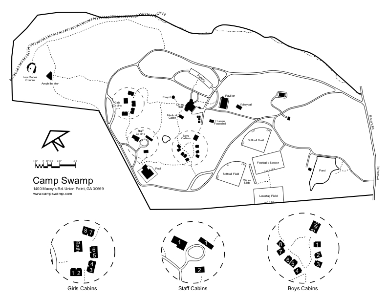
Swamp Camp Services/Swamp Camp, 1400 Maxeys Road, Union Point, GA 30669
Dining Hall Phone: (706) 352-4451 - Take Hwy 441S (Macon HWY) to downtown/old Watkinsville.
-
Hartsfield International AirportDirections from Hartsfield International Airport
- Follow directions leaving airport to get on I-20 East (Ask car rental desk for specifics).
- Take I-20 East towards Augusta.
- From the I-285 North and I-20 East connector, drive about 45 minutes on I-20.
- Get off at Exit 130 (Greensboro/Eatonton Exit).
- Take a left off the exit and drive three (3) miles (you are now on Main St.) until you get to the one light in the square of downtown Greensboro.
- Take a right.
- Take the first left (before the gas station) at the light and go behind the courthouse. This road becomes Penfield Hwy, but you will not see a sign.
- Go approximately 7 miles into Penfield city limits (unincorporated-very small sign).
- After coming into the city limits, you will go around a sharp right curve. (Red-roofed housed on this curve)
- Take the next left which is Maxeys Road. (Beasley is to the right). If you go pass the rehab facility, turn around.
- Maxeys Road turns into a gravel/dirt road.
- Go 9/10 miles on Maxeys Road (will turn into a gravel/dirt road)
- Pass the mailbox and enter through the lower double red gates on the left.
- Follow signs to park in designated parking spaces
- Please observe all traffic/speed signs
Swamp Camp Services/Swamp Camp, 1400 Maxey's Road, Union Point, GA 30669Dining Hall (706) 352-4451 - Follow directions leaving airport to get on I-20 East (Ask car rental desk for specifics).
-
Atlanta I-20Directions from Atlanta, I-20
- Take I-20 East towards Augusta.
- From the I-285 North and I-20 East connector, drive about 45 minutes on I-20.
- Get off at Exit 130 (Greensboro/Eatonton Exit).
- Take a left off the exit and drive three (3) miles (you are now on Main St.) until you get to the one light in the square of downtown Greensboro.
- Take a right.
- Take the first left (before the gas station) at the light and go behind the courthouse. This road becomes Penfield Hwy, but you will not see a sign.
- Go approximately 7 miles into Penfield city limits (unincorporated-very small sign).
- After coming into the city limits, you will go around a sharp right curve. (Red-roofed housed on this curve)
- Take the next left which is Maxeys Road. (Beasley is to the right). If you go pass the rehab facility, turn around.
- Maxeys Road turns into a gravel/dirt road.
- Go 9/10 miles on Maxeys Road (will turn into a gravel/dirt road)
- Pass the mailbox and enter through the lower double red gates on the left.
- Follow signs to park in designated parking spaces
- Please observe all traffic/speed signs
Swamp Camp Services/Swamp Camp, 1400 Maxey's Road, Union Point, GA 30669
Dining Hall (706) 352-4451 - Take I-20 East towards Augusta.
-
Columbia or CharlestonDirections from Columbia or CharlestonFrom Charleston: Take I-26 West to I-20 West; Follow the directions below.
From Columbia: Take I-20 West through Augusta towards Atlanta- Get off at Exit 130 (Greensboro/Eatonton). Take a right off the exit onto Hwy 44.
- Drive three (3) miles (you are now on Main St.) until you get to the one light in the square of downtown Greensboro.Take a right at the light.
- Take the first left (before the gas station) at the light and go behind the courthouse. This road becomes Penfield Hwy, but you will not see a sign.
- Go approximately 7 miles into Penfield city limits (unincorporated-very small sign).
- After entering the city limits, you will go around a sharp right curve
- Go Left onto Maxeys Road. (Beasley is on the right). If you go pass the rehab facility, turn around.
- Go 9/10 miles on Maxeys Road (will turn into a gravel/dirt road)
- Pass the mailbox and enter through the lower double red gates on the left.
- Follow signs to park in designated parking spaces
- Please observe all traffic/speed signs
Swamp Camp Services/Swamp Camp, 1400 Maxeys Road, Union Point, GA 30669
Dining Hall Phone: (706) 352-4451 - Get off at Exit 130 (Greensboro/Eatonton). Take a right off the exit onto Hwy 44.
-
East Atlanta: Hwy 78Directions from East Atlanta: Hwy 78
- Follow Hwy 78 through Conyers, through Monroe.
- Take a right onto Hwy 53/Hog Mountain Rd. (T's Corner/Shell is on the far left corner).
- Stay on Hwy 53 for 8.5 miles. Take a right at the light onto Experiment Station Rd/53E. (Eckerds & Publix on right).
- Stay on this road (pass police station) until dead ends at a stoplight.
- Take a right at the stoplight and drive through old Watkinsville
- At 2nd light, veer left onto HWY 15
- Take HWY 15 from Oconee County into Greene County. (Once you cross into Greene County, the mile markers will begin at mile marker 28 and decrease from there).
- Continue until you see the 18-mile marker on the left side of the road.
- Shortly after the 18-mile marker take the next left onto Shiloh Road.
- Take Shiloh Road until it dead ends.
- Go Left onto Penfield Hwy for 2.7 miles (road makes sharp right curve)
- Go Left onto Maxeys Road. (Beasley is to the right). If you go pass the rehab facility, turn around.
- Go 9/10 miles on Maxeys Road (will turn into a gravel/dirt road).
- Pass the mailbox and enter through the lower double red gates on the left.
- Follow signs to park in designated parking spaces
- Please observe all traffic/speed signs
Swamp Camp Services/Swamp Camp, 1400 Maxeys Road, Union Point, GA 30669
Dining Hall Phone: (706) 352-4451 - Follow Hwy 78 through Conyers, through Monroe.
-
Gwinnett County, GeorgiaDirections from Gwinnett County, Georgia
- Take I-85 North and exit to the right onto Hwy 316 towards Lawrenceville and Athens.
- Drive on Hwy. 316 for approx. 30 miles
- Take a right at a light onto Hog Mountain Road/Hwy. 53 towards Watkinsville
- Cross over HWY 78
- Stay on Hwy. 53 for 8.5 miles. Take a right at the light onto Experiment Station Rd/53E. (Publix on right).
- Stay on this road (pass police station on left) until dead ends at a stoplight.
- Take a right at the stoplight and drive through downtown Watkinsville.
- At 2nd light, veer left onto HWY 15
- Take HWY 15 from Oconee County into Greene County. (Once you cross into Greene County, the mile markers will begin at mile marker 28 and decrease from there).
- Continue until you see the Marker 18 on the left side of the road.
- Shortly after the 18-mile marker take the next left onto Shiloh Road.
- Take Shiloh Road until it dead ends.
- Go Left onto Penfield Hwy for 2.7 miles (road makes sharp right curve)
- Go Left onto Maxeys Road. (Beasley is to the right). If you go pass the rehab facility, turn around.
- Go 9/10 miles on Maxeys Road (will turn into a gravel/dirt road)
- Pass the mailbox and enter through the lower double red gates on the left.
- Follow signs to park in designated parking spaces
- Please observe all traffic/speed signs
Swamp Camp Services/Swamp Camp, 1400 Maxeys Road, Union Point, GA 30669
Dining Hall Phone: (706) 352-4451 - Take I-85 North and exit to the right onto Hwy 316 towards Lawrenceville and Athens.
-
Charlotte, Greenville, Triangle, NCDirections from Charlotte, Greenville, Triangle, NC
- Take I-85 S. and exit at 149 (Commerce exit). Drive across the overpass towards Athens on Hwy 441 S.
- Drive about 30 minutes. Take a right on the Athens Bypass/Loop 10/Hwy 441S.
- Stay on Loop10/Bypass/Hwy 441 and exit 4A (441/129/HWY15 Watkinsville/Madison exit). (* NOT Timothy Rd)
- Go 2.5 miles on HWY 441 South.
- Take a left at the next stoplight onto HWY 15 South / Business District Hwy 441 S. and drive into old Watkinsville.
- At 3rd traffic light veer left onto HWY 15 (pass Jittery Joes and Golden Pantry on right after veering)
- Take HWY 15 from Oconee County into Greene County. (Once you cross into Greene County, the mile markers will begin at mile marker 28 and decrease from there).
- Continue until you see the 18-mile marker on the left side of the road.
- Shortly after the 18-mile marker take the next left onto Shiloh Road.
- Take Shiloh Road until it dead ends.
- Go Left onto Penfield Hwy for 2.7 miles (road makes sharp right curve)
- Go Left onto Maxeys Road. (Beasley is to the right). If you go pass the rehab facility, turn around.
- Go 9/10 miles on Maxeys Road (will turn into a gravel/dirt road)
- Pass the mailbox and enter through the lower double red gates on the left.
- Follow signs to park in designated parking spaces
- Please observe all traffic/speed signs
Swamp Camp Services/Swamp Camp, 1400 Maxeys Road, Union Point, GA 30669
Dining Hall Phone: (706) 352-4451 - Take I-85 S. and exit at 149 (Commerce exit). Drive across the overpass towards Athens on Hwy 441 S.
Open all Close all